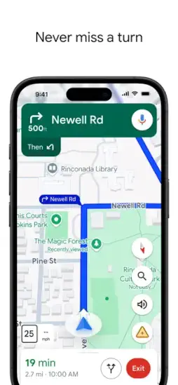
Google Maps is all in one navigation and local discovery app combines real time GPS navigation, live traffic and transit, Street View, offline maps, and rich business and review data to help you get around and explore places worldwide.
Since launching in 2005, Google Maps has become the default way billions of people find their way, discover new places, and plan their days. Whether you are driving to work, exploring a new city, or just looking for a coffee shop nearby, this app is probably already on your phone. And for good reason.
What Exactly Is Google Maps?
Google Maps is a web mapping platform and consumer app launched in 2005, now available on iOS, Android, and the web, with deep integration into Google services and third party apps. It provides turn by turn navigation, live traffic and transit info, indoor maps, Street View, saved places and lists, and local business details including hours, photos, and reviews in one interface.
Beyond basic maps, it powers business profiles, ride hailing, food delivery, and travel planning, and supports offline downloads for areas with poor connectivity. Think of it as your digital guide to the physical world. Every street, every business, every route, all in your pocket.
At the time of this post, Google Maps holds a 4.7 star rating on the Apple App Store from millions of reviews. The app size is roughly 473 MB depending on your device. Age rating is 4+ with no objectionable content. For a similar experience, check out Apple Maps.
Who Benefits Most From Using Google Maps?
Google Maps has a broad audience, and it serves them well.
Daily commuters needing real time traffic and transit updates will find the live traffic data invaluable. No more guessing which route is faster.
Travelers exploring new cities and countries will appreciate the offline maps and local discovery features. Find restaurants, attractions, and hotels anywhere.
Local residents searching for restaurants, shops, and services will rely on the reviews, photos, and busy-times data. Know what to expect before you go.
Businesses relying on accurate location data and customer reviews will benefit from Google Maps visibility. A well-maintained business profile attracts customers.
Anyone who needs reliable directions for driving, walking, cycling, or public transit will find the multi-modal routing essential. Choose your mode. Get your route.
Core Features That Define Google Maps
Turn by Turn Navigation for Driving, Walking, Cycling, and Transit
Get turn by turn directions for driving, walking, cycling, and public transit. Live rerouting around traffic and incidents. Voice guidance keeps your eyes on the road.
Live Traffic and Transit With Real Time Congestion and Delays
See real time congestion, delays, and public transport schedules. Alerts and alternative routes help you avoid delays.
Street View and 3D Imagery
Explore 360 degree street-level imagery and 3D terrain and building views. Perfect for trip planning and previewing destinations.
Offline Maps for Navigation Without Internet
Download regions to navigate without internet. Essential for travel or areas with weak signal. GPS works even without data.
Local Discovery With Ratings, Reviews, Photos, and Busy Times
Search for restaurants, hotels, gas stations, attractions, and more. Ratings, reviews, photos, and busy-times data help you decide.
Saved Places and Custom Lists
Pin home and work. Save favorites. Create custom lists like “Weekend trips” and share them with others.
Multi Stop Routing for Road Trips and Errands
Add multiple destinations. Avoid highways, tolls, and ferries. Plan efficient road trips and errands.
Lane Guidance, Speed Limits, and Camera Alerts
See lane guidance, speed limits, and camera alerts in many regions. Drive more safely and confidently.
Indoor Maps for Airports, Malls, and Stadiums
Navigate large venues with indoor floor plans and points of interest. Find your gate, store, or seat easily.
Integration and Sharing (ETA, Locations, Lists)
Share your ETA, locations, and lists with contacts. Embed maps on websites. Integrate with ride-hail and delivery apps.
Google Maps Graphics and Visual Design
Google Maps uses a clean, vector-based map design with clear roads, labels, and color coded traffic for quick comprehension. Green means flowing. Orange means slow. Red means stopped. You can read it at a glance.
The app interface is organized around search, directions, saved places, and explore, with bottom tabs and contextual cards for businesses and routes. Everything is where you expect it to be.
Users generally find it intuitive and information dense, though some complain about clutter in busy cities, occasional search flow quirks, and the battery and GPS drain when using navigation extensively.
How Google Maps Works
The daily flow is straightforward. Search or explore a place, category, or area on the map. Type a name or browse nearby.
Get directions in your chosen mode, drive, transit, walk, or bike, with live traffic and alternatives. Choose the fastest or most scenic route.
Navigate turn by turn with voice guidance, lane info, and automatic rerouting as conditions change. Follow the blue line.
Discover and save places, create lists, read reviews, and share locations and ETAs with others. Plan your next outing. Share your arrival time.
What Users Say About Google Maps
Common praise includes accurate, reliable navigation and excellent real time traffic and transit data for daily commutes and trips. Comprehensive local information, reviews, photos, busy times, and business details make it a go to for discovering places. Offline maps and multi modal routing, drive, transit, walk, bike, work well across many countries.
Common criticisms include battery drain and GPS usage during long navigation sessions, especially on older devices. Routing quirks, occasional odd walking or rural routes, sudden reroutes in dense downtown areas, or confusion in complex intersections. Search and UI clutter, some users find search results and business information overwhelming or the Android search flow less smooth than iOS.
Tips to Get the Most From Google Maps
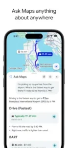
You could just open the app and type in an address. But a few Google Maps tips will help you navigate smarter, save time, and get more from the app.
Download offline maps before trips to areas with spotty data. Open the app, search for your destination, tap the three dots, and select “Download offline map.” GPS works even without internet. Your route stays available.
Set home and work for quick commute predictions and traffic alerts. Add your home and work addresses in settings. Get real time commute times and traffic alerts without typing anything. One tap to navigate.
Use multi stop routes for errands and road trips. Add multiple destinations. Reorder stops. Optimize your path. Avoid backtracking and wasted time.
Check busy times for businesses to avoid crowds. Scroll down on any business listing. See when it is busiest. Plan your visit during quieter hours. Save time and frustration.
Explore layers: Map, Satellite, Terrain, and Traffic views. Tap the layers button. Switch between views. Satellite gives you a bird’s eye view. Terrain shows elevation. Traffic shows congestion.
Use Street View to preview destinations and parking areas. Before you arrive, drop a pin and tap Street View. See the entrance, parking, and surrounding area. No surprises when you get there.
Share your ETA with friends and family during trips. Tap the “Share trip progress” button. Send a link. They track your arrival in real time. No more “where are you?” texts.
Avoid tolls, highways, or ferries in route options. Tap route options. Select what you want to avoid. Choose cheaper or simpler routes. Useful for larger vehicles or budget-conscious trips.
Apps Like Google Maps
If Google Maps does not fit your needs or you want to compare options, you have alternatives. The best Google Maps similar apps share the same focus on navigation, transit, and local discovery.
| App / Service | Main Similarity |
|---|---|
| Apple Maps | Native iOS and macOS navigation, transit, and local discovery |
| Waze | Community driven traffic, incidents, and police alerts with navigation |
| HERE WeGo | Offline first navigation and transit with downloadable maps |
| Mapbox / OSM-based apps | Customizable mapping and routing for developers and power users |
None of these replace Google Maps exactly. Each has strengths. Apple Maps offers deep iOS integration and privacy features. Waze excels at real time crowd sourced traffic and police alerts. HERE WeGo is ideal for offline travel with comprehensive downloadable maps.
For most users, Google Maps strikes the best balance between accuracy, local data, and feature breadth. The integration with Google Search and business profiles makes it a default choice.
If you are on an iPhone, Apple Maps is a solid alternative with strong privacy protections. If you want community traffic alerts, Waze is worth trying. If you travel internationally without data, HERE WeGo is excellent for offline navigation.
Conclusion
Google Maps is the default “operating system for the real world” for billions of people. Not the flashiest app, but the most depended-on for everyday movement and exploration. It is a tool you probably use without thinking about it. And that is the mark of a great utility.
The strongest angle is reliability. Accurate navigation. Real-time traffic. Comprehensive local data. Offline maps. It works when you need it, where you need it. The app is not perfect, but for most people, it is good enough. And often, it is excellent.
Who should download it? Daily commuters needing real-time traffic and transit updates. Travelers exploring new cities and countries. Local residents searching for restaurants, shops, and services. Businesses relying on accurate location data and customer reviews. Anyone who needs reliable directions for driving, walking, cycling, or public transit.
Who should skip it? People with serious privacy concerns about Google’s data practices. Those who prefer Apple Maps or Waze for specific features. Anyone who needs a dedicated GPS device for offline travel without phone dependency. But even then, the offline maps feature makes it a strong backup.
Google Maps is not trying to be a game or a social network. It is trying to get you where you need to go. And for billions of people, it does. Download it. Search for a place. Get directions. Start navigating. That is the loop. That is the map.
FAQ
Where can I get Google Maps download for my phone?
You can get Google Maps downloaded on your phone from the Official App StoreGoogle Maps downloaded on your phone from the Official App Store.
Is there an official website or help page where I can learn more about features and troubleshooting?
Yes. The official Google Maps website is here: Official Google Maps Website Link.
How do offline maps work, and how much storage do they take?
Offline maps let you download regions for navigation without internet. Storage varies by region size; a typical city map uses 100-500 MB. Downloaded maps expire after 15-30 days and need updating for accuracy.
Is Google Maps accurate for walking and public transit directions?
Yes, Google Maps supports walking, cycling, and public transit directions in most regions. Transit data includes schedules, delays, and real-time updates from local agencies. Walking directions include paths, stairways, and estimated times.